©2013, 2019 Annemarie’s Ship


The Route
The Caledonian Canal connects Inverness in the north east Fort William in the south west, some 60 miles distant.
It was constructed in the early nineteenth century by engineer Thomas Telford. Only one third of its length is man-
The canal has 29 locks (including eight at Neptune's Staircase near Fort WIlliam), four aqueducts and 10 bridges.
The Justification
The canal was originally a way to provide much-

The Construction
Because of the remoteness of the location, especially in the 19th century, work was started at both ends so that the completed stretches of the canal itself could be used to transport the required materials towards the especially remote inner reaches of the Great Glen, the central sections of the canal.
At Corpach, near Fort William, the entrance lock was built on rock, but at the other end, at Muirtown Basin in Inverness, there was 56 feet (17 m) of mud below the proposed site of the lock. To provide a foundation for the lock, rock was deposited on top of the mud and left to settle for six months before construction could begin. At the time of construction the canal locks were the largest ever built.
The labour force used on the construction proved unreliable, especially during the potato harvest and throughout the peat cutting season when other work was available. To combat the labour shortage, and in contradiction of one of the main aims of the project, providing labour for those affected by the Clearances, Telford brought in Irish navvies.
The canal finally opened in 1822 at a cost of £910,000 and over 3,000 local people had been employed in its construction. However there were compromises: the depth had been reduced from 20 feet (6.1m) to 15 feet (4.6m) in an effort to save costs.
During the lengthy construction shipbuilding had advanced with the introduction of steam-
Instead the canal has long been a magnet for tourists, whether on foot, on bike or on the water in kayak or cruiser.
The Planning
Although the route of the canal had been surveyed before, it was the Caledonian Canal Commission that paved the way for the actual construction. An Act of Parliament authorised the project in July 1803 and Thomas Telford was asked to survey, design and build the waterway. Telford worked with William Jessop on the survey, and the two men oversaw the construction until Jessop died in 1814. The design was expected to take seven years to complete at a cost of £474,000, to be funded by the Government, but both estimates were inadequate.
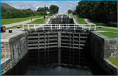
Neptune’s Staircase at Banavie, near Fort William, is the longest staircase lock in Britain lifting boats 64 feet (20 m). It consists of eight locks, each 180 feet (55 m) by 40 feet (12 m) and it takes about 90 minutes to pass through the system
The canal finally opened in 1822 at a cost of £910,000 and over 3,000 local people had been employed in its construction


The Great Glen is a remarkable geological feature, caused by a fault line in the earth’s crust along which the land has moved horizontally in opposite directions many times over millions of years.
The most significant movement has been the rocks to the north west sliding south west by several tens of kilometres. This movement has caused the rocks along the line of the fault to be crushed for up to a kilometre either side of the fault. The shattered rocks have been preferentially eroded to produce the depression that is the Great Glen, which extends from north of Inverness to the Isle of Mull, the Caledonian Canal occupying the stretch from Inverness to Fort William.
The geology of the Glen, like that of most of Scotland, is incredibly complex and it is this complexity that is behind the remarkable variation in landscapes within such a small country.